History
The History of our Streets
Images open in a lightbox when clicked, and are linked in a gallery
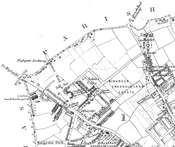
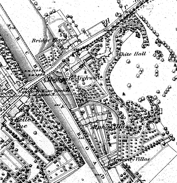
The Islington Local History Centre at Finsbury Library have a map on sale, for a pound or two, that dates from about 1853. It is called A Plan of the Parish of St. Mary Islington, with the boundaries of the Several Ecclesiastical Districts, and Parochial Wards. The Upper Islington ward is vast, covering everything between Seven Sisters Road and Hornsey Lane, which was the northern boundary of the parish: and it is mostly open fields, with ribbon development along the Holloway Road and Hornsey Road. In four areas, building societies have estates laid out. The St. Pancras Freehold Land Society has two, and the National Freehold Land Society and the Birkbeck Freehold Land Society have one each. The WHPARA area has Whittington College, a development called St. John’s Ville, and fields.
The almshouses however are long gone, and the Miranda Estate stands in their place. The fields on John Dower’s map agree fairly well with the 1849 Tithe Apportionments Map, and the 1870 Ordnance Survey, published in 1873. Let us first bring together what little we know about the fields, and then move onto the roads.
The Manor
Our fields are boxed in by four roads - the Archway Road, finished in 1813, Hornsey Lane which has been there since time immemorial, Duval’s Lane or Tollington Lane (the Hornsey Road) which is just as old, and St. John’s Way, originally St. John’s Road, partially laid out in 1845. The hundred or so acres enclosed by this box were, round about the year 1600, copyhold of the Manor of Saint John’s Clerkenwell, later known as the Manor of Saint John of Jerusalem. There is a sketch map of the manor, from the Victoria County History, at British History Online.
The Court Books of the manor can be seen at the London Metropolitan Archives. The books go back to the early 17th century, and the copyhold tenants of one half of our area - the Trays, or Trayers, or Trees Hill Estate - can be listed from before 1650 to the middle of the 19th century just by leafing through them. There were manorial courts of different sorts held at fixed times of the year, the tenants (collectively the homage) were obliged to attend, and the business of the manor was conducted according to age-old manorial custom. Using false weights and measures, or felling timber without permission, brought down fines payable to the lords and ladies of the manor: and the death of a tenant was recorded and a “proclamation” made for the heir to come into court. On proving his title to inherit the copyhold, the heir paid a handsome “fine” to the lords of the manor and was graciously admitted as tenant. This was all written down and added to the court roll: and the Court Books in the London Metropolitan Archives are presumably copies of those rolls. A copyholder held his land “by copy of court roll.”
The Trays Hill Estate was the north-east part of our area. Starting on Hornsey Lane, if we trace a line down the back garden walls of the east side of Ashmount Road, on through the gap between numbers 32 and 34 Dresden, then the gap between 25 and 27 Cheverton, down across St. John’s Way and then bear east to meet the bottom of Hornsey Rise, we will have traced the western fence of the estate. The other sides were bounded by Hornsey Lane and Hornsey Rise. John Dower’s map divides the estate into five large fields.
The south-western half of our area is not so simple. Our knowledge of a couple of the fields, fronting Hornsey Lane, is so defective that we do not know whether they were copyhold or not. What we do know runs as follows.
Meadow and Pasture
Christopher Wase of Grays Inn - not to be confused with his namesake the eminent scholar - bought a house and seven fields at Upper Holloway from William Daniell of Grays Inn, for £1430, in year 20 of James I, i.e. in 1622. The surviving record of the sale tells us that there were two sitting tenants, Thomas Robinson and the Widow Sharp, both of whose leases had some years to run: and the land was copyhold of the Manor of St. John’s Clerkenwell, so that Wase was buying a lease himself. Daniell undertook to transfer the tenancy to Wase at the next manorial Court, and pay any fine or other dues, and “cause and procure the foresaid Christopher Wase to be admitted tenant.” Wase had paid half the money down, and promised to pay the rest at a date to be determined. The house and seven fields are described thus:
One Capitall Messuage or Mansion house builded with Brick or with other materialls lyinge and being in upper Holloway in or neere unto the prshe of Islington in the said Countye of Midd And all buildings barnes stables gardens Orchards proffitts easements and appurtenncs to the foresaid Messuage used or belonging in upper Holloway aforesaid
And three Closes of meaddoe or pasture there sometimes of Bartholomewe Westley,
And one Close of meaddoe or pasture to the foresaid Messuage adioyning conteyning by estimation Nine acres and an half,
And one other Close conteyning by estimation one acre and an halfe of Land more or lesse in Upper Holloway aforesaid,
And one field called Oakefield otherwise Cockshutfield conteyning by estimation Fowerteene acres, situate lying and beinge in upper Holloway aforesaid sometimes in the tenure or occupation of Peter Browne or of his Assignes,
and one other Tenement with thappurtenncs sometimes in the possession or occupation of David Owyn or of his Assignes
And all other the Customary and Coppihold lands tenements and hereditaments Whatsoever of him the said William Daniell houlden of the Mannor of St Johns Clerkenwell in the said County of Midd by the rod at the will of the Lord according to the Custome of the foresaid Mannor
London Metropolitan Archives: Halliday Collection 166
The seven fields amounted to something like 50 acres. Wase wrote his will in October 1643, and died within days. An Inquisition Post Mortem, held probably in 1645, fixed the acreage: it also found that he was seized of – owned – half of the Manor before he died. Its findings, once you penetrate the legal jargon, are clear enough:
Et ulterius Jur prd sup sacrm suu prd dicunt qd prd Christoferus Wase in bri prd noiat in vita sua fuit seita in dmco suo ut de feod de et in medietate Manij Sci Johis Hierusalem als Clarkenwell als St Johns Clerkenwell cu ptin in Clerkenwell et in poch sci Sepulchri et Sci Egidij extra Creplegate Iseldon als Islington Hollowaie Highgate et Hornsey in prd Com Midd Ac de et in uno Capto Mesuag cu ptinen scituat et existen in upper Hollowaie in poch de Islington prd in Com Midd prd Ac etiam de et in uno alio Mesuag et quinquagint acr terr cu eorum ptinen scituat iacen et existen in Hollowaie in poch de Islington prd in Com Midd prd nup du vixit in tenure sive occupatione prd Christoferi Wase p antea existen pcel terc [sic] tent p Copiam Rotul Cur de Manij Sci Johis Hierusalem prd in Com Midd prd
― And further the foresaid Jurors declare on oath that the foresaid Chistopher Wase named in the said writ was while living seized in his demesne as of fee of and in a moiety of the Manor of Saint John of Jerusalem otherwise Clarkenwell ... and of and in a capital messuage with appurtenances situate and being at Upper Holloway in the said Parish of Islington in the said County of Middlesex, and also of and in another messuage and 50 acres of land belonging to it situate lying and being at Holloway ... lately during his life in the tenure or occupation of the said Christopher Wase formerly being a parcel of land holden by copy of Court Roll of the said Manor of Saint John of Jerusalem ...
The National Archives: PRO C 142/778 number 108
Wase here has two houses besides the 50 acres, and the land seems no longer to be copyhold, although Wase is still a tenant. His exact legal title to the land is, luckily, not our immediate concern: what we find some years later is that two “lords of the services” had been appointed, for whatever reason, to uphold manorial rights.
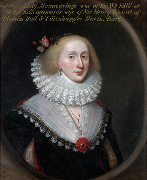
Wase’s will left all his property to his wife Judith, née Gore, and after her death to his daughters Hester and Judith. Hester, the older and already married, was to have all the land in Buckinghamshire, and Judith, who was maybe eight years old when he died, was to have the land in Middlesex. The sisters changed this arrangement in 1656, when they decided that the inheritance should be divided equally between them. They met early in December that year to regularise the agreement at a Court Baron of the lords of the services. One of these gentlemen was a London grocer (i.e. a man who trades wholesale, “in the gross”), the other, William Gore of Tooting, was in all probability a cousin or uncle of the sisters. The Court was held in Christopher Wase’s house at Upper Holloway, and the record of the meeting gives us a better description of the property. It comprised the “Capitall Messuage or Mansion house built of brick,” together with
all those closes of meadow and pasture ground in Holloway aforesaid to the said house now adioining as they are now divided conteining by estimation Fifty acres or thereabouts That is to say
The Home Closes conteining by estimation ten acres
The Five acres close conteining by estimation five acres
one other close conteining by estimation Four acres
one other close now divided into Two called The Crowne feilds conteining by estimation Fourteen acres
one other close now divided into Two called The Cockshotts conteining by estimation Sixteen acres
one other close called the Pingle conteining by estimation One acre
London Metropolitan Archives: Halliday Collection 169
There are now six fields, not seven: one of the closes, “five acres adjoining Hornsey Lane,” has been added to the Buckinghamshire portfolio in order to balance the division. We still do not know which field this was. But that is the last we hear of Courts Baron and manorial rights. At some point the six fields ceased to be held of the “lords of the services,” but when and how we do not know.
Lease and Release
Wase’s daughter Judith died before her mother, perhaps in childbirth, and her husband, George Master or Masters, inherited her land. There was a Chancery Court action, and a ruling that Hester, and her second husband Sir Henry Blount (her first was Sir William Mainwaring), were to choose their half of the inheritance: and they took the 50 acres. Deeds recording Chancery Court rulings, leases and mortgages in 1675, 1676 and 1714 reproduce the same list of fields, word for word. The 1714 document gives details of a mortgage by demise in 1697 by which a grandson of Hester’s, Henry Blount, leased it for 500 years to one Thomas Carter. A figure of about £1500 seems to have been involved, and the deal comes back to haunt us a century later. A granddaughter of Hester’s, Dame Hester Tyrrell, sold the land at the end of March 1732. In those days, and for a century afterwards, two separate deeds were necessary to transfer ownership of land. First you made a lease for a short period and for a negligible sum of money, often five shillings or indeed a peppercorn: this was then followed by a second deed, a release in which real figures were mentioned. Dame Hester first leased the 50 acres for six months to three gentlemen, whose names tell us nothing. The following day she released it to the same three, but also to Watkinson Wildman of Cheapside, a goldsmith, and Susanna his wife, and a John Jacob as well. Finally, and the same day, a third deed was drawn up, assigning the land to the original three, and also to Katherine and William Hawkins, and Joshua Bayes. Of these nine people, the Wildmans are the ones to keep in mind.
Watkinson Wildman, the son of an apothecary from Sheffield, came to London and apprenticed himself to William Browne, citizen and goldsmith of London, in 1706. The apprenticeship was to run seven years, and the young man engaged not to contract matrimony, frequent gaming tables or playhouses, or in any way let down his master, for the full term. In 1714 he was admitted a freeman of the City, and in 1733 his son Samuel, following in his father’s footsteps, was in turn admitted. If Watkinson married Susanna promptly in 1713, when his apprenticeship ended, Samuel would have been twenty in 1733.
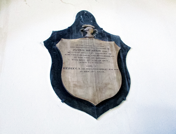
On the 3rd September 1795 Samuel Wildman, goldsmith - either a grandson of Watkinson, or a venerable octogenarian - wrote his will, leaving all his property in Islington, freehold and leasehold, to Edward Wingfield Dickenson and Newton Dickenson, grandsons of his late cousin Wingfield Wildman of Tamworth. In June 1800 Edward Dickenson raised money on the inheritance: two houses at Upper Holloway with 50 acres of land – the Home Closes, the Five-acres Close, one other close containing four acres, the Great Crown Field, the Cockshotts containing 16 acres now split into two, and the Pingle at one acre. The only difference so far is that the one house has become two again. In August 1808 all this land was bought by James Hunter of Bucklersbury in the City of London, and now we are given more accurate measurements. The list now runs
| the Home Close | 9 acres | 1 rood | 16 perches |
| Five Acre Close | 4a. | 3r. | 11p. |
| Hornsey Lane Close | 4a. | 1r. | 13p. |
| Crown Field | 13a. | 1r. | 7p. |
| Cockshalls or Cockshotts | 12a | 1r. | 34p |
| The Pingle | 2a. | 0r. | 24p. |
In the interval the Cockshotts have lost four acres, the Pingle has doubled in size, and Hornsey Lane Close has got a name. Otherwise this is Judith and Hester’s land as it was in 1656. The total acreage is 46 acres 1 rood and 25 perches: the four acres lost by the Cockshotts account for the shortfall.
James Hunter proceeded to sell the land off, starting a week after he had bought it: and we now begin to get some idea of where these fields were.
Our Fields
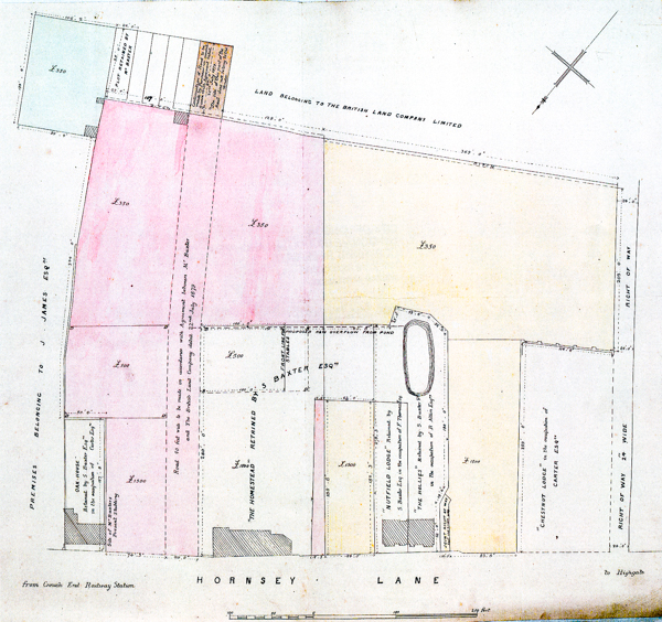
The Home Close can be roughly located by one or two pointers. In 1811 James Hunter assigned to the Highgate Archway Company a rood of land (1,210 square yards), the north-west angle of the Home Close. In 1838 William Hunter – James had both a brother and a son called William – was selling a piece of land, formerly part of the Home Close, west of the Archway Road and with part of the Highgate Archway Tavern standing on it. The same year he sold the rest of the Home Close, excluding that part on the north side taken for the Archway Road. It is clear enough that the Archway Road cut through the Home Close, slicing off the corner that lay under the Archway Tavern. Fields do not as a rule cross roads: so the Home Close lay south of the Archway Tavern, fronting Highgate Hill and the Holloway Road, and stretched out east. The straight stretch of St John’s Way from the Methodist church to the Medical Centre must cut across the Home Close.
The Medical Centre stands in the north-west corner of the Five Acre Close. In 1845 William Hunter sells to Thomas Tolfree 3000 square yards of land on the corner of St John’s Way and Ashbrook Road, and tells us that it was formerly part of a close called the Five Acre Close. St John’s Way was a proposed road in 1845, without even a name, and plans show it turning sharply south into Ashbrook Road (originally St John’s Road South) and going no farther east. The S-bend the road now follows at that junction is to get round Mr. Tolfree’s land. It follows that the Five Acre Close is south of St John’s Way and probably east of Ashbrook Road, although as with the Home Close the other field boundaries are uncertain.
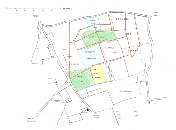
Hornsey Lane Close is located by a footpath, 24 feet wide, which crossed the middle of it and was a right of way to the Crown Field. The width of the footpath is mentioned in deeds dating to 1809 and 1838, and we are given a drawing of it in 1881 when Samuel Baxter sells half of the field to Thomas Dence. That Hornsey Lane Close is the original “one other close containing by estimation four acres” is an assumption based partly on the position of the field in the list, but mainly on the stipulation, when the Close is sold in 1809, that what is being bought is defined in “a certain Indenture bearing date the 16th day of June 1797 & made between Henry Blount of the one part & Thomas Carter of the other part & the term of 500 years thereby created.” The date 1797 is a slip of the clerk’s pen. We already know about the mortgage by demise of 1697.
The Crown Field is the best defined of them all. The eastern half is drawn for us in 1879, with the proposed Dresden Road across it, when Samuel Baxter sells it to British Land. The deed tells us that the western half is separated by a footpath (now Cressida Road) “lying between the said piece of land now being described and the remainder of the said Close formerly called Great Crown Field and theretofore belonging to the late Sir Henry Vane Tempest but afterwards to the Revd. Henry Causton.” We will meet the Rev Henry Causton again: Sir Henry, coalowner, racehorse owner and MP for Durham, moved in the very highest social circles and was the father of Lady Frances Anne, born in 1800, neglected as a girl (they had hoped for a boy) and later in life a fabulously wealthy no-nonsense Victorian businesswoman. Sir Henry’s connection with the Crown Field is far from clear, but other deeds refer to him having both halves of it at one time: our imagination can supply his horses grazing between Dresden and Cheverton, when they were not running races. It was Sir Henry that commissioned Stubbs’s painting Hambletonian, Rubbing Down.
The Cockshutts or Cockshalls are not so readily identified for us. The tithe apportionments map of 1849 names the Cardinal’s Hat, the field in which the workhouse was later built, so that field is ruled out. The land farther east is the Trays Hill estate, and the rest of the Archway Road is built through the Two Long Closes, then on land belonging to the Causton family of Highgate, no part of Christopher Wase’s 50 acres. There is no room left for 12 acres, except the Shakespeare Roads. William Hunter, in December 1844, sold to George Penson the planned St John’s Road and St John’s Road South, the field where the Shakespeare Roads now are, and large parts of the land south of St John’s Road, describing this land as parts of the Home Close, the Five Acre Close and the Cockshalls otherwise Cockshuts. If we are right about the other two fields, then the Cockshutts are underneath the Shakespeare Roads.
That leaves the Pingle. In 1806 the Dickenson brothers lease it to Charles Thomas Dupree or Depree, and tell us that it fronts the high road from London to Highgate on the west, abuts on land occupied by Mr Godson to the north and the east, and on land belonging to the Dickensons to the south. Now we know that Thomas Godson had the Two Long Closes and the Spittle at one time: but we do not know what other land he had, and there is no virtue in jumping to conclusions. The best we can do with the Pingle is to say, all suggestions are welcome.
Having got the two estates in place - Trays Hill on the Hornsey Rise side, Christopher Wase’s land filling much of the western side - we can draw in the two boundary roads on the west and south, the Archway Road (1813) and St John’s Road (1845).
Archway Road
The first moves to petition Parliament for the Archway Road were made in 1809, and the landowners whose fields were going to be requisitioned were well aware of it. Starting at the foot of Highgate Hill land was taken from the Home Close - “taken” is the word used in the only document we have seen – and north of the Home Close the Two Long Closes were acquired, reaching up as far as the back garden fences of Harberton Road. These 17 acres were bought from William Marsh and the Woodyear family. From there to the Archway itself, intended to be a tunnel beneath Hornsey Lane, land was acquired from the Causton family of Highgate.
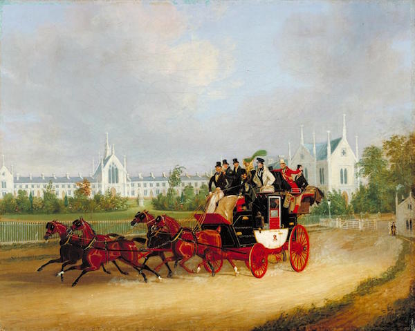
In February 1765 Charles Causton of Highgate had been given by Robert Thomas of Highgate, his prospective father-in-law, five properties on the south side of Hornsey Lane, with coachhouses, stables, gardens and “all those closes or fields of meadow or pasture land on or adjoining thereunto.” Quite how much land this amounted to we are not told, nor what the status of the land was, freehold or copyhold. In 1799 Charles had passed these properties to his son Thomas Causton, Prebendary of Westminster, again on the occasion of his marriage. In May 1810 a solicitor specialising in property, William Whitton of Great James Street, Bedford Row, leased 14 acres from Thomas Causton for 30 years at a rent of £200 a year. In August Whitton assigned the same land to the Highgate Archway Company for the whole period. The road was opened in 1813, charging 6d. for a horse-drawn cart or carriage, 3d. for a horse and rider, 2d. for a donkey and 1d. for a pedestrian. The Highgate Archway Company obtained in 1822 a mortgage by demise, for 1,000 years, on the road, the bridge and the Two Long Closes from the Stables, a Stoke Newington family, and the following year the Stables mortgaged the Two Long Closes to the Mercers Company for 990 years at £120 per annum. The Whittington College almshouses were now built on four acres fronting the new road. The spoil from the roadworks, still heaped up ten years after the road opened, had to be shifted first.
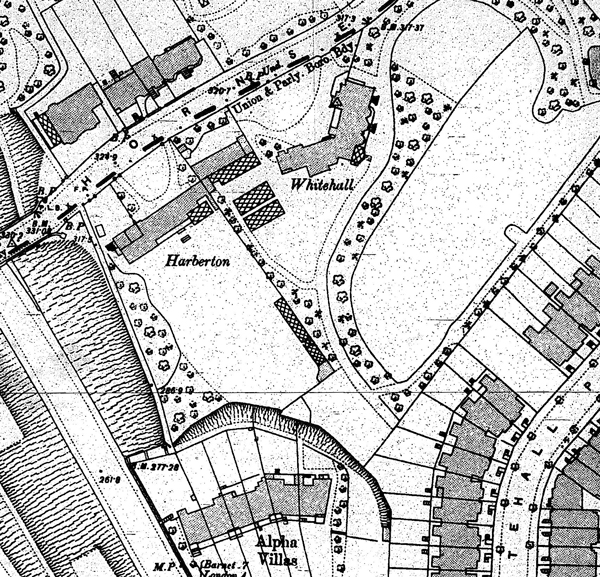
John Dower’s map shows us a short road along the north side of the almshouses called Thomas Street: this was a proposed road in 1838, and lay pretty much where Pauntley Street now runs into the Miranda Estate. Flowers Mews, which is still with us, was built after 1855 and ran at an angle to the south side of the College.
To return to the Caustons for a moment, they drop tantalising hints of houses which were inside the Conservation Area but which we no longer have. They leased three roods and three perches - a little under 4,000 square yards - just our side of the bridge to William Tombleson, bookseller, in 1834, and he built a house on it which might or might not be the first manifestation of Harberton House. Thomas Henry Causton, vicar of St. Michael’s Highgate and the son and heir of Thomas, built a house on three acres some time before 1838 which might or might not be Whitehall. The Caustons had acquired the south-eastern half of the Crown Field by that date.
More tantalising still, the Rev. Henry Venn, one of the great Anglicans of the 19th century, leased a house on Hornsey Lane from Thomas Henry Causton at an annual rent of £105 from 1834 to 1848. It is unclear which house this was, but it was certainly the other side of the bridge, and is almost certainly now underneath St. Aloysius School. The most we can claim is that Henry Venn lived a stone’s throw outside the WHPARA area.
St. John’s Road
The first we hear of St John’s Road is in December 1844, when it is an “intended new road,” along with the sharp turn south that we now call Ashbrook Road. This first plan shows no intention of continuing towards the bottom of Hornsey Rise: what it shows instead is the start of Miranda and Prospero Roads, jutting into what are clearly still fields. The new road was necessary to connect the envisaged St John’s Ville with the junction at the foot of Highgate Hill. How much of a road it was during the early years, or how much a country lane, is a moot point. The name was presumably in the air from the outset, but the first we see of it in black and white is an advertisement in the Times of March 21st 1850 for “eight very eligible freehold building sites, most desirably situate, in a healthy sheltered situation, with valuable frontages to St. John’s-road, near the Junction and Archway roads, Highgate-rise.” At a guess this is eight of the 25 Oxney Villas standing between the Methodist Church and Miranda Road, long since demolished.
Our Oldest Standing Houses
Our oldest extant houses are on Hornsey Lane. James Hunter sold the Hornsey Lane Close to the Whitehead brothers, stonemasons and statuaries, in August 1809. In his will, dated to 1813, James Whitehead left his half of the close to his brothers John and William. In William’s will, written in 1824, there is no mention of the close. The Whitehead trail runs cold.
“Particulars of sale” were advertised in 1827, in which at least the eastern half of the close was to be sold off. An auctioneer, William Davies, acquired lot 3, the site of what is now number 98 Hornsey Lane, in September, and in October a builder, William Blofield, bought lot 4 for £180. He was already leasing it at the time of the sale, and for all we know already building on it. The following July, after raising more money, he bought Davies’ plot: and by December 1829 he was mortgaging number 98, “the Messuage or tenement lately erected thereon by the said William Blofield,” for a further £450 on top of the £700 he already owed. In 1832 a George Bateman leased number 96: later in the year both houses were mortgaged for an additional £230, two years after that Blofield was bankrupt, and both houses were sold to Samuel Bult of Holmes Terrace Kentish Town, furnishing ironmonger.
The inference is that number 98 was built between 1827 and 1828, and number 96 at about the same time. The drawings attached to deeds are no very certain guide to what was standing on the land, if anything. Our best indication is the phrase “lately erected.” If the house had dated to 1829 it would have been “newly erected.” The nearest we can get is that number 98 was put up in the years immediately preceding 1829.
Blofield moved out of number 98 in 1834, and the Bults moved in. A nonconformist, freeman of the City of London, 33 years old and ten years married, Samuel brought with him his wife Sarah, a five-year-old son called Samuel and a daughter Hannah, not yet one year old. By 1837 he had let number 96 to James Dear, a linen merchant, and his wife Mary, and the two families stayed put into the 1860s. Samuel died in 1862; the following year Hannah married Walter Samuel Partridge, a shipbroker, of North Hill Highgate; Sarah died in 1867, and Partridge immediately put both houses up for sale. The advertisement informs us that number 96 was “let to James Dear, Esq., who has been many years in occupation, at the exceedingly low rent of 60l, per annum.” Neither house seems to have sold. Number 98, now called Chestnut Lodge in the directories, went to Walter Carter, a builder, in 1878, and we have found no trace of number 96 ever being sold. In the 1891 census Catherine Dear, widow of independent means, lived there, and the house was identified as Blowfield. By 1903 however the house name had been suppressed, and she was occupying number 44 Hornsey Lane.
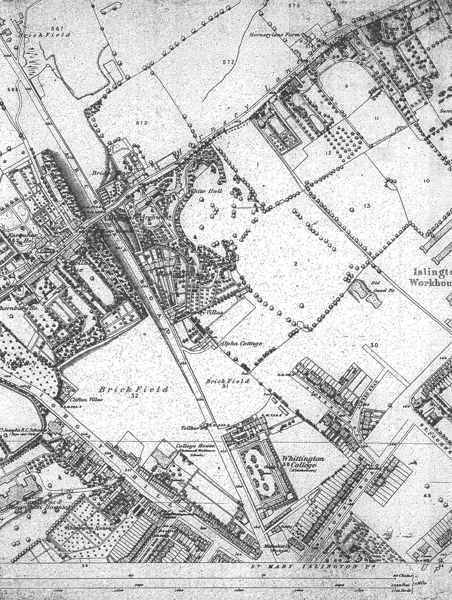
Alpha Villas (now numbers 80-88 Archway Road – see the 1870 Ordnance Survey map below) were the next new building started, if not the first finished, in the Conservation Area. The Highgate Archway Company bought from the Caustons the lease on one acre and one rood of the land just by the four-mile stone, and in 1848 they mortgaged it to the Colson family, who were involved in collecting the tolls. At least one of the six houses was partly finished the same year, when the Colsons found themselves bankrupt. Not much happened for three years: in 1851 the London Express offered for sale “Leasehold residence in the Archway-road, Highgate, let for 60l., with three unfinished houses adjoining, and the foundations of two other houses, the whole held for 999 years from 1840 at 25l.” Assuming that the standing house was number 1 Alpha Villas, then number 2 was certainly standing in 1854, and number 6 was advertised still unfinished in 1856.
The six new houses bordered the Causton’s Whitehall estate, and a steep bank separated them on the north and east. The bank is topped with an arched boundary wall of stout brick, the shallow arches now choked with earth but perhaps once filled with trellis. How old the existing wall is cannot be determined, but it is very thick: and as a rule of thumb, the thicker a wall, the greater its age.
Notice - Two Houses - Archway-road, Upper Holloway. MR. MURRELL begs to inform the public, that the TWO RESIDENCES, Alpha Villas, Archway-road, Upper Holloway, not being disposed of at the late Auction, he is instructed by the Mortgagee to effect an immediate SALE, by Private Contract: the price is, therefore, only £400 each. The next house was sold for £750, and the next door but one lets at £60 per annum. - Auction and estate offices, 1, Walbrook, City.
The Times, Wednesday June 11, 1856
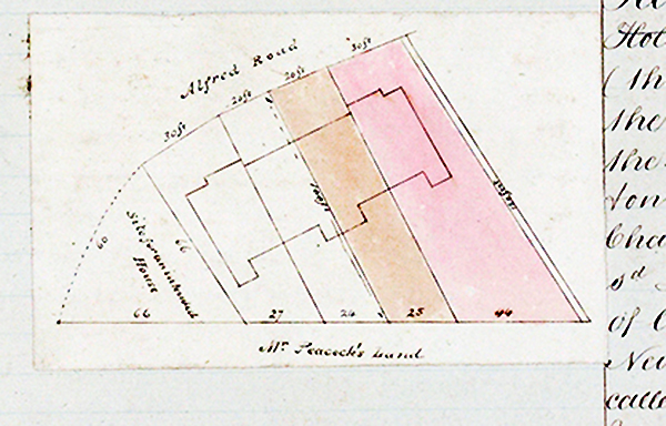
Miranda (Albert) Road and Lysander (Alfred) Road, our first streets after St John’s Road itself, were planned together. William Hunter sold the roughly 12 acres to George Penson, cheesefactor, in 1845, who sold them on immediately to George Flowers, brickmaker, Thomas Arbuthnot Whitter Esq. and Charles Martin, gentleman. A mortgage was raised the same year, and in either 1851 or 1854 the mortgage was bought up by Whitter. Five other parties, as well as Whitter, Flowers and William Bowles, builder, had an interest in the development of St. John’s Ville, and in 1855 the seven others were bought out by Bowles. The sum involved is not recorded. A cousin of Thomas Arbuthnot, John Rogers Whitter, acquired the copyhold of 30 acres south of St. John’s Road in 1836 for £2000, and enfranchised it from the manor in 1854 for twice that. By that yardstick Bowles might have paid £1600 for 12 acres.
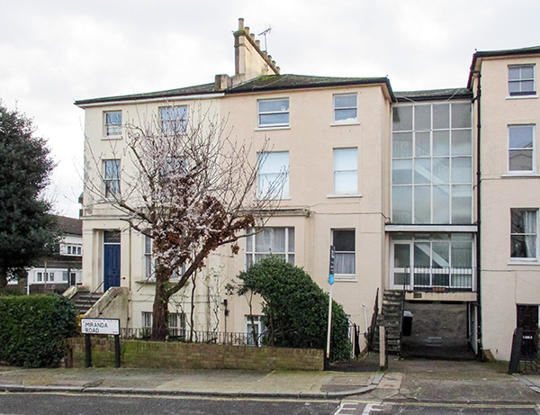
Our earliest surviving houses on Albert Road are numbers 9 and 11 (originally 5 and 6), leased partly built in May 1852 to Charles Harrison, gentleman by Whitter, Flowers, and Joseph Charles Bowles, a builder and presumably a relative of William. In July they leased numbers 13 and 15 (originally 7 and 8) to Elizabeth Clark, spinster, and in September numbers 17 and 19 (9 and 10) to Harrison. That side of Albert Road stopped there: John Dower’s map, dated about 1853, is inaccurate in showing five pairs of houses. The 1870 Ordnance Survey map shows three.
The terrace of four houses now known as 4 to 10 Lysander Grove were leased half-built in November 1852 by Harrison and Bowles to another builder, Joseph Barnes. All four blocks on the eastern side of Albert Road were standing in February 1856: fourteen houses, numbered 19 to 32, were leased at once. The numbering shows that a further twelve houses were planned for the west side, but we have to wait until the 1880s for more action in the Shakespeare Roads. Prospero and Parolles were both planned in 1852 if not earlier, and judging by John Dower’s map, the original Cressida too: but for some reason work came to a halt. Long before it started again, bricks had been laid on Hazellville.
Extensive and Beautiful Views
The copyhold of Trays Hill had been bequeathed to John Osborn of St. Albans in 1766. In 1794 he changed his will, leaving the tenancy in trust for his daughter-in-law Dorothy, and explicitly cutting out his son, in particular his son’s debts. After Dorothy his grandsons were to inherit, one after the other. Before Dorothy died in 1825 both of her sons had changed their name, by royal licence, to Jenkyn: and her oldest, the Rev. John Jenkyn, clerk in holy orders, of Duesden House in the Parish of Biddenden, paid a fine to the Manor of £460 for the tenancy.
In 1857 he put the whole estate up for sale. The Times for August 25 announced the auction in fourteen lots, by Messrs. Prickett & Sons, of
the highly eligible and very valuable ESTATES, copyhold of the Manor of St. John of Jerusalem, and a small plot copyhold of the Manor of Highbury, containing together 50a. 2r. 14p., close to the omnibus station at the Hanley Arms. In immediate contiguity to Highgate, Crouch End, and the Hornsey Station on the Great Northern Railway; the whole estate presenting one of the most desirable building sites north of London ever offered to public competition, being within five miles of the General Post Office, commanding extensive and beautiful views, situated on a gentle eminence, and the buildings already erected in the neighbourhood being of a first-class character.
The auction was not a runaway success, and some of the same land was advertised for sale again in October. Undeterred, the Rev. Jenkyn went ahead and enfranchised the estate from the manor, paying, on May Day 1858, £2016 18s 9d for the freehold. His plan was ambitious. Two long roads were proposed, connecting Hornsey Lane with the foot of Hornsey Rise, and buyers of the plots of land were obliged by the contract to build their portion of the road. Trays Hill Hall, and seven acres of ground around it, were sold to William Thomas Sargant, colonial produce broker, in 1858: and Sargant sold four acres in 1861 to Jonathan Hazell of No. 24 Gloucester Street, Clerkenwell, wholesale jeweller. A year later Hazell sold a house on the corner of Hornsey Lane and Hazellville Road (now number 140 Hornsey Lane) to Eleanor Foxwell. As with St. John’s Ville, Hazellville was not built in a day. The first and second houses at the top of Hazellville (now numbers 116 and 114) were building in January 1863, the 7th and 8th houses down the road (numbers 104 and 102) were leased, at £6 a year, in 1865. Sargant was leasing houses, now only to be seen in old photographs, across the road in 1871 and later.
An acre of land just south of Sargant’s purchase was bought by Collet Dobson Collet in 1859, and he built himself a house on the west side of Hazellville Road called Sunny Bank (‘Sunnyside’ on the 1870 Ordnance Survey map). We now know what is left of it as number 1 Dresden Road. The house was in existence by 1860, and Clara Elizabeth Collet was born there in September of that year. The Dictionary of National Biography says that the Dobson Collets were friends of the Marx family, and that the young Clara was a particular friend of Eleanor Marx.
Drains, Paupers and Missionaries
Throughout these years we hear of drainage problems at St. John’s Ville. Albert Road drained somehow - it had no proper sewer - down the hill into the open sewer along St. John’s Road and caused it to overflow. The correspondence between the Vestry and Mr. Bowles, Mr. Wells, Mr. Biggs of Holloway, and Mr. Badger of Rotherham ran on until 1863. The Badger family were South Yorkshire solicitors, and Benjamin Badger, Barrister at law, of Eastwood House Rotherham, was the last recorded lord of the manor of Highbury, the other side of Hornsey Road. But what the interest of Messrs. Wells, Biggs and Badger in St. John’s Ville was is yet to be clarified. Maybe Bowles called on them to witness that when sewers are dug past standing houses, subsidence can result. Possibly the uncontrolled drainage was what stopped further building.
Back on John Jenkyn’s land, the Metropolitan Board of Works, the precursor of the LCC, sanctioned the laying out of Sunnyside Road in February 1864, and gave permission to a Mr. Read to lay the gullies and drains. Whether Mr. Read was a developer, a builder or the representative of one of the Freehold Land Societies we cannot say. The road was laid out, but only the southern end saw any building for a number of years. The 1870 Ordnance Survey map shows arable land on both sides of the road from the orphanage to Hornsey Lane. Milbourne (now the Redwood Court flats), on the north-eastern edge of the conservation area, appeared some time before 1880, when staff were needed:
A Respectable GIRL WANTED, about 18, to take charge of a little girl, and to assist in light housework. Good plain needlewoman. Apply at Milbourne, Sunnyside-road, Hornsey-lane, N.
The Times, November 18, 1880
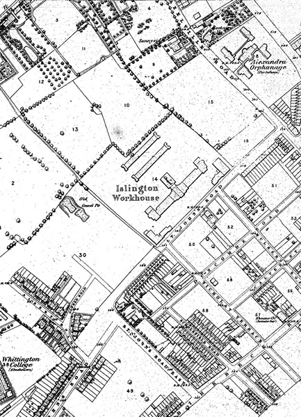
The big development, to return to the 1860s, was along St. John’s Road, where the Guardians of the Parish acquired the Cardinal’s Hat and opened the new Islington Workhouse in 1865. High ground was healthy ground – the air was cleaner – and hospitals, schools and asylums for the old tended to gravitate towards Highgate. The London Missionary Society rented Farquhar House, across the road from Henry Venn’s residence, between 1863 and 1869, as a finishing centre for missionaries, a half-way house between smoky London and the great world overseas. Highgate village was famous for its pubs as well, and was a healthy place for an evening’s drinking. Holloway Road, by way of contrast, was well supplied with off-licences.
Two of the missionaries who trained at Farquhar House married daughters of William Thomas Sargant. The Rev. Thomas Haslam married Sarah, and the Rev. William Lee married Sophia. Sarah sailed to Madras on the Barham, 1000 tons, arriving on June 11th 1865, and was married at Vepery nine days later. She had three children, two boys and a girl, Ada Emily. Sophia sailed out in 1868, and Thomas Haslam married her to William Lee at Coimbatore in December of that year. Six months later however Haslam died, of congestion of the brain, 29 years old and ten days before Ada was born. Sarah came home with the children and took a house on Hargrave Park Road.
By 1868 the little terrace of three houses called Archway Villas (later the northerly end of Whitehall Parade, and now the slip road from the southbound lane of Archway Road into Pauntley Street) had been erected. Once again the Times tells us about
Numbers 1 and 2, ARCHWAY VILLAS, Archway Road, Highgate. Held for 15 years unexpired at £7 each ground-rent, and most desirable for occupation or investment, being within three minutes’ walk of the Favourite omnibus terminus.
The Times Tuesday August 18, 1868
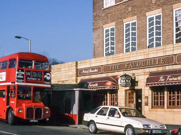
If the Favourite terminus was three minutes away, it it ought to have been at Archway: but in living memory there was a Favourite pub on the other side of Elthorne Park, at the Junction of Hornsey Rise and Beaumont Rise.
Bricks
The 1870 Ordnance Survey Map shows Archway Villas, and adds a worrying detail. Between Archway Villas and Whittington College the two-acre triangle of grassland flanking Archway Road, a remnant of the Two Long Closes, is identified as a Brick Field, i.e. a piece of land where bricks are made. An even bigger brick field covers the rest of the Two Long Closes between Archway Road and Highgate Hill. The bricks had to be fired on the spot, and on days when the brick heaps were burning, the smoke will have blown off eastwards over the fields and over the workhouse. So much for the clean air.
As London spread out northwards, the brick heaps must have moved with it. In Our Mutual Friend, chapter 4, Dickens gives us a glimpse, in “Holloway, north of London”, of
a tract of suburban Sahara, where tiles and bricks were burnt, bones were boiled, carpets were beat, rubbish was shot, dogs were fought, and dust was heaped by contractors.
Let us hope that our brick field was not like that.
The Islington Gazette for April 13 1888 mentions that a small iron chapel, “vulgarly called the tin tabernacle,” was erected in Sunnyside Road in 1875. The congregation - the newspaper does not mention which denomination, but it sounds like the Hornsey Rise Baptists - had first met in a house across the road in 1870.
Cheverton, Dresden and the first Gresley
Thomas Fox, builder, had raised £3000 in 1873 to start ten houses on Hazellville Road, then numbers 20 to 29 and now numbered (the other way) 55 to 73. He got approval to begin Cheverton Road in 1874, and in December the following year he had put up terraces on both sides of a cul-de-sac, and was leasing
the 4 messuages or tenements thereon erected & known as Nos. 9. 10. 11. & 12. Nos. 9. & 11. being the 5th and 6th houses on the right hand side Nos. 10. & 12. being the 5th & 6th houses on the left hand side of the said Cheverton Road going from Hazelville Road.
London Metropolitan Archives: Middlesex Deeds Register 1875 Book 29 number 1032.
The numbering is surprisingly modern.
In September and October 1877 a successful marine engineer, Samuel Baxter, failed to get approval from the Metropolitan Board of Works for a new road to be called Mayfield Road, to lead out of Hazellville Road, and “for the formation of a continuation of Cheverton-road”. The following December however an application was granted
for approval by the Board of a Plan for the formation of new roads to lead out of Hazleville-road, Hornsey-lane, Islington, and for the widening of a footpath between St. John’s-road and Hornsey-lane in connection therewith ... on condition that no barrier be at any time erected, or other obstructions caused to the free use by the public of the said roads, and that the names “Cheverton-road, N.,” (in continuation), “Dresden-road, N.,” and “Gresley-road, N.,” be approved for the same.
Metropolitan Board of Works Minutes 13 December 1878
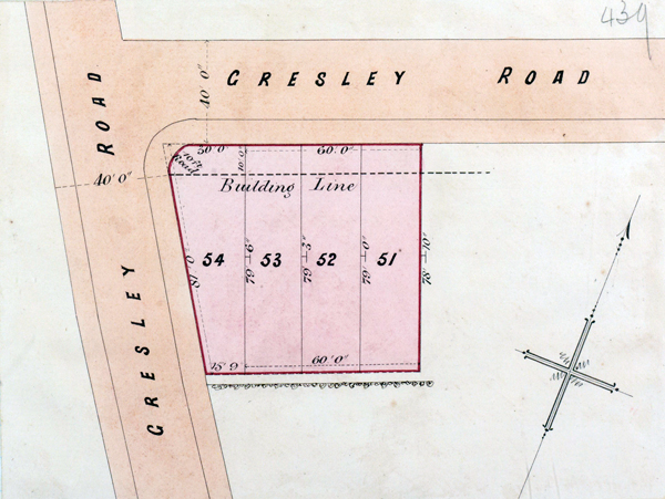
Mayfield and Dresden Roads are probably one and the same project. A wide footpath ran between Hornsey Lane and St. John’s Road, 24 feet wide down to the Crown Field, and the new streets Cheverton and Dresden were intended to join it. The proposed Gresley Road was just a matter of widening the path between Cheverton and Hornsey Lane. It shows up in deeds dating from the mid-1880s. The place-name Gresley might have been associated with the hillside for hundreds of years. It comes from the Old English for “gravelly glade,” or maybe “gravelly grove,” and an old gravel pit is shown on the 1870 Ordnance Survey map roughly where Parolles and Cressida Roads meet. But this is guesswork.
Mr. Samuel Baxter had acquired the north-eastern half of the Crown Field and Collet Dobson Collet’s acre, which adjoined it. After failing to get approval for his Mayfield Road, he sold the land to the British Land Company, and it was their scheme which was approved. The name Dresden must originate with British Land, and it is legitimate to wonder if it was the name of one of the directors. The company was intimately connected with the National Freehold Land Society, which had an estate on the other side of Hornsey Road in the early 1850s. The Building Societies Act of 1836 gave no powers to the freehold land societies to buy land, and British Land was set up in 1856 to obviate that problem. The company issued particulars for both proposed roads, including a lithographed plan, at Mr. Collier’s auction at the Myddleton Hall, Islington on November 1st 1880. They proceeded to sell off plots of ground along Dresden and Cheverton to builders, Dresden following the northerly hedge of the Crown Field, Cheverton winding round the southerly hedge. The dates of some of the houses on Cheverton show how leisurely development was. Lots 102 to 116, the land beneath Cheverton Lodge, were bought in 1881 by John Henry Scott, solicitor, and the 1920 Ordnance Survey map shows the land still undeveloped. The terrain was presumably too daunting. Lot 68, underneath Becky’s corner shop, was followed by lot 69, probably number 27 Cheverton: lot 70 was sold in 1890 to Joseph Henry Kirner, Assistant Superintendent of Telegraphs, of number 16 Ashmount Road.
In May 1878 the Metropolitan Board of Works ordered that Albert Road be renamed Miranda Road, and that the houses be numbered as they still are, that is, numbers 1 to 19 (the first four, numbers 1 to 4 Albert Place, appear on John Dower’s map, and have made way for the entrance to the Miranda Estate) and numbers 2 to 32. Two years later William Bowles submitted a plan to build Prospero Road, and to extend Miranda and Alfred Roads. The plan was sent to the Building Act Committee, and was never heard of again.
Ashmount and the second Gresley
Samuel Baxter meanwhile had bought up the five acres bounded by Hornsey Lane Close on the west, the Crown Field to the south and Trays Hill on the east, a field which is a good candidate for the “five acres adjoining Hornsey Lane” of 1656. It had belonged in 1812 to John Lloyd and more recently to John Killick, a farmer who died, probably at Oak House on Hornsey Lane, in 1874. Baxter had the land already in 1876, and by 1881 had acquired the adjacent half of Hornsey Lane Close. In July 1881 he sold this land to Thomas Dence, a property developer and financier, and in the same month Dence was given the Board’s approval for “the formation of new roads to lead out of the South side of Hornsey-road [sic], and of the names ‘Ashmount-road, N.,’ and ‘Gresley-road, N.,’ in continuation, for the same”. The latter was “in continuation” because it led off the Gresley Road approved in 1878. Ashmount runs along the hedge of the Trays Hill estate, Gresley along the hedge of the Crown Field. Dence figures in the deeds of all the properties in Gresley and Ashmount, and one of the stipulations is that he will maintain the footpaths and roads “until the parochial or other Authorities shall take upon themselves the repair of the said Roads footpaths and drains as shown on the said Estate Plan”. As with the Vestry, a surveyor apportioned the cost and the householders paid their share. Dence did not maintain a workforce of men with shovels, and the British Land Company put the drains in. Alfred East, who gave his name to East Terrace on Dresden Road, built a number of the houses in Gresley, and Thomas Fox built a terrace on Ashmount. Plot 55, where number 80 Whitehall Park now stands, was bought in December 1881 by Catherine Dear, widow of independent means, of Hornsey Lane―almost certainly number 96 Hornsey Lane. She did nothing with the land for ten years.
Dence’s local involvement spilled over from these two roads. He sold the plots which now support numbers 24 to 32 Dresden Road to William Bailey, lodging house keeper, in 1882: and he sold a large plot of land fronting Hornsey Lane in 1883, land which now lies under the Whitehall Park School site. The buyer was a John Crawley, the price was £700, and the plot - 80 feet along the road by 190 feet deep - lay between The Hollies and Nutfield Lodge on the east and The Homestead, Baxter’s residence, to the west. The 1894 Ordnance Survey map shows a house called Englefield on the plot.
Samuel Baxter grew grapes in one of his greenhouses, and spent time admiring them. As often as not, however, he was to be found in his study (where he sometimes took his meals) poring over such nautical questions as windlass capstans on merchant ships. On a Thursday in August 1887 his wife Sarah returned from a drive and sent a servant to tell the master that she was back. The girl looked high and low - the Homestead had ten bedrooms, two bathrooms and a billiard room as well as Baxter’s study - and came back baffled. Sarah then sent one of her sons, who found his father in the greenhouse with his head in a ten-foot-deep water tank sunk into the floor, quite dead. The tank had a stout wooden lid, but the hinges had broken and the lid for the time being was propped to one side. The coroner decided that Baxter had been inspecting his grapes and had thoughtlessly stepped back. The Ham and High, reporting the death, said that Baxter “was well known and much respected in the neighbourhood.” Sarah died in May 1890.
Paperwork
In an ideal world we could all look at our deeds, identify the Thomas Dences, and know when and how our streets came into being. Deeds however are always incomplete, and great quantities of them have been sent to landfill. Keeping old papers is hard work, and expensive, and solicitors and building societies have better things to do than maintain archives. For more on deeds generally, a good starting point would be the British Records Association.
Which were the first houses in any of our streets can be established by looking at the building plans. These were deposited, under the Local Government Act of 1858, at the Vestry Office, and are now kept by Islington’s Building Control people. In the past, the plan of any of our houses could be looked at for a modest fee, but in present circumstances that service is not currently available.
Logically, the sewer has to be there before the houses. Mr. Read in 1864 was putting the “gullies and drains” down for Sunnyside Road. After the sewers came the houses, built on numbered plots. That left the footpaths and the tar macadam. The Vestry, backed up by Statute law, got the roads metalled and paved, and then charged the householders for the pleasure. The Vestry’s surveyor worked out the estimates and the cost was apportioned among the owners. At the beginning of the 1880s an average bill for this work might have come to a little over £17 per household, although some properties got bills in the hundreds. Cheverton Road had been told to pay up already by the end of 1881. A year later the Sewers and Buildings Committee recommended
that the powers of the Metropolis Local Management Acts 1855 and 1862 be put in force to compel the Owners of property abutting on Dresden Road Hornsey Lane to make the Roadway and flag the footpaths there.
Vestry Minutes December 1 1882
This demand was opposed on the grounds that Dresden Road was only “half built over”.
Brave New Streets
Miranda Road - the terrace from number 21 and upwards was started in 1879 and finished by the end of March 1883 - was told to pay up that November, and in December the Sewers and Buildings Committee were in hot pursuit of Dresden, Gresley and Ashmount all at once. Once the streets were metalled, the Vestry could turn its attention to lighting and rubbish collection. In June 1883 the Lighting Committee reported to the Vestry that a new lamp should be placed in Gresley Road. That might be the one outside what is now number 86 Whitehall Park.
The Shakespeare Roads mushroomed rather more smoothly than their neighbours up the hill. On Friday 6th October 1882 a builder, Thomas William Beaves of Kentish Town, obtained the Board of Works’ approval for his amended plan to build Parolles Road, Lysander Grove, Prospero Road and Cressida Road: which was to be L-shaped, running up the hill from Saint John’s Road and turning sharply left to join Parolles Road. The gap between numbers 39 and 41 Parolles, opposite number 26 on the corner of Prospero, is where Cressida and Parolles were to meet. In April 1883 Charles Harrison was leasing the newly erected numbers 3, 5, 7 and 9 Lysander Grove, and across the road numbers 12 to 20, to Beaves, who mortgaged them on the spot to Arthur Griffith Underwood, a solicitor. In September of the same year the same financial hopscotch was performed with numbers 2 to 12 and 7 to 17 Prospero Road: the plans attached to the deeds suggest that the terraces were complete as far as number 32 and number 29. Harrison, Beaves, Bowles and Underwood were also busy on St John’s Road in these years. Numbers 89 to 97 were built by March 1881: numbers 119 to 127 were standing already in 1880, and numbers 99 to 117 are described as new in 1883. Houses on the western stretch of Parolles Road were being leased by 1885, mostly at £7 per annum.
In 1887 Thomas Beaves died, and Charles Harrison (the nephew of the original Charles Harrison of the Albert Road days) called in a firm of auctioneers, Edwin Alfred Carter and Frederick Charles Carter, to push ahead with Cressida Road. The sewers for the street had been approved in 1885, and improved sewers were approved in 1888. Leases drawn up by the Carters start from 25 December that year, but the houses were going up in 1891: numbers 1 to 23 Cressida were
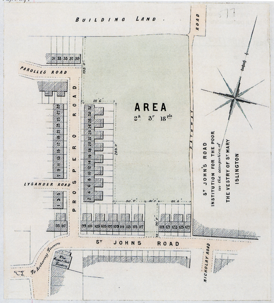
sold while still building in February, number 31 in March, numbers 30 and 32 Parolles in October. A number of them were put up by John Norris, builder, and in that same month he gave his address as 31 Cressida Road. He completed number 24, across the road, in the same year. The rapid construction of the street is impressive, but then houses of modest dimensions were needed fairly urgently. Some of the big villas on Miranda were home to four or five small families by the 1890s.
Grand Finale: The Whitehall Estate
In 1888 the last piece of the local jigsaw began to take shape. The Times kicked off with:
Whitehall, Hornsey Lane, within seven minutes’ walk of Crouch End Station and only half an hour’s drive from the City and West End. A highly attractive Freehold Family Residence, occupying an exceptionally choice position, at about 320 ft. above sea level, in the midst of beautiful old grounds of upwards of three acres, sloping down south. With possession. Also the adjoining residence, known as Harberton, standing in pretty grounds of 1¼ acre, of the annual value of £160.
Mr. EDWARD MILLARD will SELL, at the Mart, on Monday, June 18th, at 2, in two lots, the above FREEHOLD PROPERTIES.
Lot 1 comprises the well-appointed family residence known as Whitehall, delightfully situated on the south side of Hornsey Lane, to which it has a frontage of about 425 ft. The house is in every way a thoroughly comfortable and well-planned modern residence and contains a handsome tower, with observatory, tower smoking room, 11 principal bed and dressing rooms of good dimensions, three servants’ bedrooms, two bathrooms, five spacious and lofty reception rooms, including billiard room, and excellent domestic offices. Well removed from the house is capital stabling for five horses. The grounds, which are inexpensive to maintain, are adorned with a variety of very fine timber trees and shrubs, and include a pretty tennis lawn shaded on two sides, vinery, peach-house, greenhouse, &c., and paddock, the whole comprising upwards of three acres, and so richly timbered as to afford almost perfect seclusion. With possession.
Note - This property is well adapted for a college, convalescent home, asylum, or other public institution, or could advantageously be developed as a building estate.
Lot 2 - The adjoining residence, known as Harberton, with stabling and pretty grounds of about 1¼ acre, leased for 28 years unexpired at £20 per annum, with reversion to the rack-rent, estimated at £160 per annum.
Particulars of Messrs. Gush, Phillips, Walters, and Williams, Solicitors, 3, Finsbury Circus, E.C.; and of the Auctioneer, as above.
The Times May 26 1888.
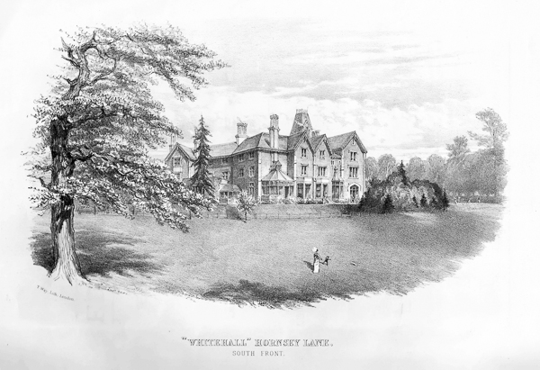
In 1881 the Causton family had sold to a certain George Wills, Australian merchant, 14 acres of ornamental and arable land, including the remains of the Great Crown Field, and Whitehall itself, with the house built by William Tombleson. We know far too little about George Wills, beyond that he was already leasing the house and the 14 acres at the time of the sale. By 1888 he had improved his estate with the triangular brick field, giving him a clear frontage to the Archway Road from Alpha Villas to Thomas Street and Whittington College: and he sold 17 acres, excluding the two houses, to John Cathles Hill in September that year, mortgaging Hill to the tune of £19,000. The upshot of the auction advertised in May is not clear. The house may not have been sold. Three years later the directories show Samuel Lammas Dore, of Brooker Dore and Company, metal merchants, living at Whitehall. There was a George Wills, at the end of the century, who was chairman of La Yesca Gold and Silver Mines Ltd. If it is the same man, then Wills and Dore may have met on the metal exchange.
The grounds of Whitehall featured a tree-lined drive down past Alpha Villas, in other words as far south as the bottom leg of the modern Whitehall Park, and a strip of land was taken from it to make room for the new road. The Whitehall Estate, designed as a piece, was started in 1889, the year after the sale. Whitehall Park and Gladsmuir Road were completed, apart from St. Andrews Church, in 1891, and Harberton Road in 1893. In leases John Cathles Hill gives his address as The Neuk, Whitehall Park. This was the corner house at number 71, six bedrooms, three reception and a bathroom, and he lived there for four or five years before moving to an address in Archway Road: a bomb cleared the site between October 1940 and June 1941. Hill leased rows of houses to builders, and they leased them on one at a time: to George Cathles Porter, of Bedford Villa, Cheverton Road, eighteen properties on Whitehall Parade in July 1891, numbers 26 and 34 Whitehall Park in September, and in October numbers 4 to 18 Whitehall Park and number 1 Gladsmuir. To Frank Phillips, of number 60 Gladsmuir Road, he leased twenty-four houses on Gladsmuir at £7.10s.0d a year each. To Fred Barrett he leased eight houses on Harberton Road in October. And so on and so forth. Since all these gentlemen were “builders”, it is not clear who built what. Numbers 88 to 94 Hornsey Lane went up at the same time, and should perhaps be considered part of the estate.
Tidying Up
The row of shops in Whitehall Parade, still remembered by older residents, served the new roads. Our other shops were under construction at much the same time. They were all built by Edwin George Jackson, who started out with his brother as a coal merchant, dealing with the Great Northern Railway in Stroud Green Road, before moving into property. He built the seven shops on Hazellville Road in 1888, numbered then from 35 to 45A (a baker’s in 1892, now Rewild the florists). He acquired lot 68 on Dresden Road - from the launderette to Whitehalls Estate Agents - in 1889 and lot 97 on Cheverton - from Whitehall Wines to Cappucino - in 1890. He put four shops on each parcel of land, finishing lot 97 first, in 1891, and lot 68 a year later. These last he sold to a victualler, a fancy goods dealer and an auctioneer’s clerk, but what sort of shops opened at first is not at all clear. Kelly’s Directory for 1892 lists a dairy, a bootmaker, a greengrocer, a butcher and a grocer on Cressida Road, but does not tell us where they were. There were ten shops built by then, so that half of them had yet to open for business.
The ancient footpath climbing from St John’s Road up to Hornsey Lane had been altered, in 1865, to follow the eastern boundary wall of the workhouse, and it now joined British Land’s Gresley Road, which stopped dead at the same boundary wall. The Vestry now took the logical decision to join up Cressida and Gresley. They announced their intention (in the Times for April 4th 1891) to close the footpath and to form
a new highway in lieu thereof, leading from the said St. John’s Road (between Nos. 117 and 119) in a north-westerly direction for a distance of 482 feet or thereabouts, partly through a piece or parcel of land belonging to the Guardians of the said parish, and partly through the grounds of the said St. John’s Road Workhouse, also belonging to and in the occupation of the said Guardians, to join the said Gresley Road, which said road leads to Hornsey Lane, in the parishes of St. Mary, Islington, and Hornsey, such new highway to be the width of 40 feet or thereabouts, and being already partly formed and laid out and known as Cressida Road aforesaid.
The said Vestry had finished the said Cressida Road by the end of 1892. The stretch of Gresley Road running between Cheverton and Whitehall Park was added to it in 1891, by the LCC, the successor to the Metropolitan Board of Works. The remnant of Gresley running from Whitehall Park up to Hornsey Lane was perhaps given to Whitehall Park at the same time. Number 80 Whitehall Park - Kent House - figures as number 42 Gresley Road in the 1901 census.
Meanwhile the Sewers and Buildings Committee had pounced in November 1891, demanding that the householders on the two new roads Whitehall Park and Gladsmuir pay up to have the roads metalled and paved “to the satisfaction of the Vestry.”
It was, of course, convenient for everybody in the parish (workmen and tradesmen as well as the inhabitants of these salubrious new estates) to have decent roads. Potholes were not the only nuisance. In unmade roads, the problem was exacerbated by mud, horse droppings and “the shooting of dust”.
The Vestry had a hard time of it disposing of household waste. Decomposing organic matter easily found its way into the streets, and where a road was not “under jurisdiction”, all the Vestry could do was send round the Sanitary Inspector to serve health notices. In 1882 there were complaints about rubbish in Cheverton Road, and the Inspector duly served notices. There was little else the Vestry could do. In 1895 they were provoked into trying to make the regular disposal of waste compulsory. The Vestry Clerk wrote to the Times:
Although it has been the practice in the past to send dust-carts twice or thrice a week through most of the streets of the parish, very few of the 45,000 householders have availed themselves of the “advantage”.
Experience has rather shown that owing to the frequent opportunities afforded for removal many householders have been ready to fall back upon any excuse for deferring it.
The vestry, being of opinion that the regular and, if necessary, compulsory removal of refuse from every house in the parish at short, but fixed intervals is of more value to the health of the inhabitants than the exercise by individual householders of their discretion as to whether it shall be removed three times a week or once in three weeks, has issued a notice the main purport of which is to inform them that the dust-cart will call for the refuse at each house in the parish on a fixed day in each week, and that its removal will be insisted upon.
The Times, June 18 1895
The London Government Act was passed in 1899, and Islington Council took over from the Vestry. The Sewers and Buildings Committee never got a chance with our final street. Whitehall was sold for demolition (but not in fact demolished) in 1910, and Fitzwarren Gardens was laid out in the richly-timbered grounds, splitting and passing on both sides of the house. Building started soon after the sale, and continued through the Great War. The name Fitzwarren is said to be the maiden name of the wife of the celebrated Mayor of London, Richard Whittington: and that, as the storybooks say, is where we came in.
The Princess and the Pauper
The Story of the Alexandra Orphanage
In late May or early June 1879 Robert Dibb received a reply from Francis Knollys. Whether Mr. Dibb opened the letter himself, or whether he was handed a letter that someone else had read first, we do not know. The circumstances were not ordinary. He was a pauper, almost as old as the century, and a resident of the Islington Workhouse. Francis Knollys was the private secretary to Albert Edward, the Prince of Wales.
On May 22 1879 the newspapers carried the announcement that the Prince and Princess of Wales were going to visit the orphanage on Hornsey Rise, and inaugurate the new buildings there. Alexandra of Denmark was a great beauty, and drew enormous crowds wherever she went. The People’s Palace was named after her, and so was the orphanage on Hornsey Rise. The newspaper announcement aroused feverish local interest, and the other institutions in the area began to think, if she can go there, she could come here too. Whatever actuated Mr. Dibb – his own initiative, or someone else’s suggestion – he took up his pen, and wrote to Marlborough House. And back came Mr. Knollys’s reply. We have not seen it, but it ran more or less, Thank you for your letter and yes, they will drop in at the workhouse.
The Alexandra Orphanage had come into existence in October 1864. Joseph Soul and Frederick Barlow, members of the Board of the Orphan Working School on Haverstock Hill, were the moving spirits. Their idea was to take in fatherless children from among the decent working population, as young as two years old, and bring them up to be suitable candidates for the Orphan Working School, which took in youngsters from the age of eight. Barlow offered two houses, rent free, as premises. The other essential ingredient, if a house was to be run, was women. Soul’s daughter Elizabeth took on the role of secretary to the Ladies’ Committee. Who it was wrote to get permission to use Alexandra’s name, we do not know, but she gave her permission, and agreed to subscribe ten guineas a year. The immediate patronage of the Prince and Princess of Wales was the best start in life any charity could hope for.
The two houses were numbers 5 and 6, Albert Road, St. John’s Ville. We would now call them Miranda Road, N19, and the houses are numbered 9 and 11. The orphans, like so many members of Parliament, were elected. Children’s names were put forward – in principle from anywhere in the kingdom, but in practice mainly from the London area – and the Governors and Subscribers met twice a year and cast ballots for each child. The infants with most votes got a place. This system had defects, and the time wasted by lobbying and special pleading to get children a place tested everyone’s time and patience. But in the world of Samuel Smiles and Self-Help, it may have been the best system available. No religious discrimination of any kind was permitted, and children with any kind of infectious disease were of course sent straight back where they had come from.
The orphans were listed in the annual reports, with a note as to their circumstances. Most were fatherless, some had neither parent. An entry reads:
Adams Alice Georgiana, born January 15, 1864; father not been heard of for several years, was a wholesale milliner, Kingsland. Seven children, six dependent upon mother. Elected May 1866.
By the time Alice Adams entered the orphanage, the houses on Albert Road were evidently too small. Despite all precautions, there had been an outbreak of whooping cough, and there were not enough rooms to separate the sick from the well. Worse, little ones had been elected, and brought in, and then proved to be cholera cases. There were forty-seven orphans by the end of 1866, and already some of these were being looked after by friends and supporters in their own homes. The Governors started looking for freehold land to build houses for themselves.
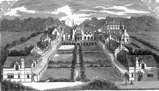
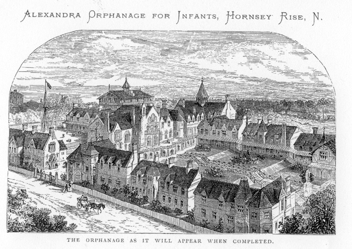
Their plan was new to England, but had worked well on the continent. It was to build a number of separate cottage-homes, each to house 25 or 30 infants, with two qualified nurses in each. The school, dining hall, laundry and offices were to be central, and a matron was to be in charge of the whole site. Although the charity’s income for 1866 was £2,785, by the end of that year land had been bought on Hornsey Rise for £3,367. 17s. 3d – most of it presumably borrowed. The foundation stone was laid in July 1867 by the Duchess of Sutherland, and twelve months later a Grand Bazaar was held in the new buildings on Hazellville Road, although it is doubtful that the whole site was ready. By then there were sixty orphans to be housed. In 1869 the orphanage was certainly up and running, and there were a hundred children in its care.
Money problems dogged the enterprise. A great deal of debt was cleared in 1875, but the schoolroom that year was not adequately equipped and the teaching suffered. The number of orphans had risen to 130, but there could have been more – four of the cottage-homes were standing empty. The money was not there to fill them up. These problems were temporarily solved in 1877, when the decision was taken to merge the Orphanage with the Orphan Working School. A grand fund-raising festival was set up the same year, attended by the Prince of Wales, and £8,000 came in on the night. Much of that sum was earmarked for improvements on Hazellville Road – including the schoolroom. By 1879 a new schoolroom, laundry, boiler house, and housing for the teachers was completed, as well as a bigger playground, covered with asphalt. It was to inaugurate these improvements that the Prince and Princess of Wales came.
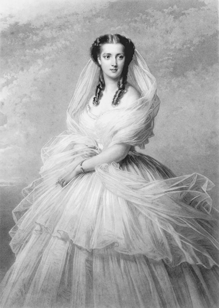
As usual, it rained on the day. The Royal landau had the hood up as it came up Camden Road and Holloway Road, pulled by four horses with a postilion on each, and an outrider in scarlet livery. From the Nag’s Head to the orphanage thousands lined the route, and in places flags and bunting stretched across the streets. The workhouse was the first stop, during a heavy shower. Islington Workhouse gave shelter to a thousand paupers, not counting children, and was reckoned one of the largest and finest in the kingdom - “certainly,” said the Times correspondent, “a very spacious, well-built, well-ventilated, clean and orderly establishment.” The steps and the windows of the workhouse were crowded, the women in white bonnets and red cloaks and the men in stout blue coats, and because the hood was up they saw a closed landau. As it entered, a little girl came up and handed in a nosegay of flowers for the Princess. These were in a silver “handle”, a tiny vase, which the paupers had paid for, and which was inscribed in Danish, “to Her Royal Highness the Princess of Wales from the 1,369 paupers and schoolchildren in Islington Workhouse, 1879”. They went inside for the speeches, and when they left, although a light rain was still falling, the landau was opened, and they drove away to resounding cheers.
Cheverton Road in 1879 was a project, not a street, and the only way to the orphanage was along St John’s Road and up Hazellville. At the orphanage the Duke of Cambridge, the President of the Orphan Working School, was waiting for them. As they entered, the Royal Artillery Band played the national anthem and a guard of honour from the Middlesex Rifle Volunteers presented arms. The orphans, dressed in blue, formed a procession, and led the way into the dining hall, where speeches were made. The Royal party then inspected the new schoolroom and unveiled a commemorative tablet. After that a ceremonial act of charity was played out. The Times reported that:
No less than 165 ladies went one by one to the dais, handed to the Duke of Cambridge a little white purse with blue cord, containing in each case at least five guineas, and curtsied to the Princess, who graciously acknowledged the salute. Some of the ladies were very young indeed. Little girls of two or three toddled along, assisted by their little brothers. Many donations were made in other forms, and it was roughly estimated that £1,500 was collected.
The younger orphans then took centre stage. While the Royal party sat and watched, they lined up on both sides of the schoolroom and sang a song, raising their arms and clapping their hands in time. What variations were involved in this coordinated exercise we cannot begin to guess: let us suppose that all the little ones got it right all the time. The older orphans, doubtless feeling ill done by, were outside, under the glass-covered walkway that lined the gardens and the lawn.
When the distinguished visitors left, the number of conveyances had swelled to four, and they passed slowly in front of the Aged Pilgrims’ Asylum at the corner of St John’s Road and Hazellville, waving to the old people gathered at the windows.
Back at the workhouse, there was cake for tea that night. What Robert Dibb, aged 72, was feeling, we have no way of knowing.
Sources
Islington Archives, Finsbury Library - Vestry Minutes: Parish Rates Books
The British Library - Ordnance Survey of England. Book of Reference to the Plan of the Parish of St Mary in the County of Islington. Southampton, 1873: Madras Ecclesiastical Returns: Athenaeum and Daily News, Madras: Dictionary of National Biography: The Islington Gazette: 19th-century British Newspapers: Alexandra Orphanage annual reports
London Metropolitan Archives - Middlesex Deeds Registry: Metropolitan Board of Works Minutes: Court Books of the Manor of Saint John of Jerusalem: Halliday Collection: City of London Freedom Admission Papers: Victoria County History volume 8: directories: Islington Tithe Apportionments Map 1849
Highgate Literary and Scientific Institution – The Whitehall Estate Highgate prospectus 1888
The Times digital archive
National Archives, Kew – Will of Dorothy Osborn: Will of Christopher Wase: Will of Samuel Wildman: Inquisition Post Mortem, Christopher Wase
Charles Booth Life and Labour of the People in London. Third Series: Religious Influences vol. 1 London North of the Thames. London, 1902 mentions the off licences in Holloway Road on page 160. The book does not touch on our area. His remarks on the 1894 St Pancras Vestry (pages 190-191) should be compared with what he says about the Islington Vestry (pages 156-158). For a Vestry election meeting see for instance the Islington Gazette for May 9 1888.
Eilert Ekwall The Concise Oxford Dictionary of English Place-names 4th edition 1959. Derives Gresley and Greasley from Old English grēosn-lēah meaning a “gravelly lēah”, a lēah being a glade or grassy area in the woods, or sometimes the woods themselves, or pasture and meadow: page 292 “the exact meaning of lēah is generally doubtful in place names”.
With thanks to Brenda, Frances, Shirley and George for showing us their deeds, to Bill for pictures, and to Elaine for lending us Streets With a Story. The Book of Islington by Eric Willats, second edition 1988. And to the staff at the Islington Local History Centre, the London Metropolitan Archives, and the British Library for their superhuman forbearance.